 N環球
N環球 
Urgent update: Polo remains Category 4; private forecast sees possible Sunday-night Baja landfall
Polo had maximum sustained winds near 250 km/h as its outer bands brought heavy rain, dangerous surf and coastal-flooding risk to southwestern Mexico. AccuWeather projects a possible late-Sunday-to-Monday landfall north of Cabo San Lucas, but the timing and location can still change.
Polo had maximum sustained winds near 250 km/h as its outer bands brought heavy rain, dangerous surf and coastal-flooding risk to southwestern Mexico. AccuWeather projects a possible late-Sunday-to-Monday landfall north of Cabo San Lucas, but the timing and location can still change.
Why it matters
Polo remains an extremely powerful Category 4 hurricane. Coastal Michoacan, Colima, Jalisco, Nayarit and Guerrero face heavy rain, life-threatening rip currents and coastal flooding. Residents and travellers in southern Baja California should follow current NHC, Mexican weather-service and civil-protection alerts.
Full report
Reuters reported at 15:05 UTC on September 24 that Polo remained a Category 4 hurricane with maximum sustained winds near 250 km/h. The U.S. National Hurricane Center said some near-term strengthening was possible and that Polo should remain a major hurricane for several days as its outer bands brought heavy rain ashore.
Private forecaster AccuWeather projects that Polo could make landfall north of Cabo San Lucas on the Baja California peninsula late Sunday into Monday, possibly after weakening to Category 2. This is not a certain landfall outcome; the track, intensity, timing and location can still shift in later forecasts.
The NHC forecast another 50 to 100 millimetres of rain, with isolated totals near 150 millimetres, along coastal Michoacan, Colima, northern and southern Jalisco and Nayarit. It warned that swells could produce life-threatening surf, rip currents and coastal flooding.
Hurricane-force winds extended roughly 65 kilometres from Polo's centre and tropical-storm-force winds roughly 205 kilometres. Authorities near Cabo San Lucas restricted beach access and closed the local harbour. Acapulco and Zihuatanejo had already been closed to all navigation, with small-craft restrictions at several other ports.
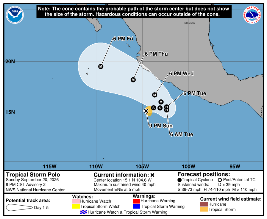
The page image is an earlier NHC forecast cone issued September 21 and is retained only to show the storm's general location; it does not represent the latest September 24 intensity, track or warning area. Readers should use current NHC, Mexican weather-service and local civil-protection alerts.
Verification status: corrected/updated. The NHC confirmed Polo's intensity, rainbands and marine hazards; the landfall projection is explicitly attributed to AccuWeather. News value: S-level breaking news. Origin: Mexico, Latin America. Primary section: Environment/disaster. Related regions: Latin America and worldwide. Source update: September 24, 2026, 15:05 UTC. Page updated: September 25, 2026, 03:55 UTC.
This report is an original summary based on verified sources, not a verbatim reproduction.
💬 Comments
No comments yet. Be the first!